Log in
All resources
Create a design
14,157 Free Artworks of Bibliotheque Nationale
bibliothèque nationale de france
guillaume sanson
maps by willem and johannes blaeu
chorographia britanniae (1741-1742)
etchings by charles meryon in the bibliothèque nationale de france
charles méryon
meryon (delteil 042)
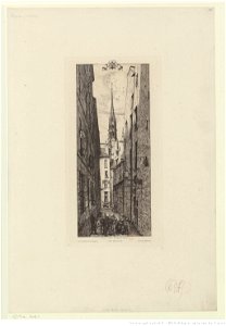
notre-dame de paris from rue des chantres
collections de la bibliothèque nationale et universitaire de strasbourg
andré saglio
old maps of whole wales (alone)
1670s maps of wales
depictions of horace vernet
romanticism
chorographia britanniae (1741-1742)
18th-century maps of surrey
chorographia britanniae (1741-1742)
18th-century maps of shropshire
rome in the 1550s
high renaissance
chorographia britanniae (1741-1742)
18th-century maps of leicestershire
chorographia britanniae (1741-1742)
18th-century maps of bedfordshire
chorographia britanniae (1741-1742)
18th-century maps of devon
chorographia britanniae (1741-1742)
1740s maps of wales
chorographia britanniae (1741-1742)
18th-century maps of derbyshire
maps of ancient italy by philipp clüver
1620s maps of italy
zee kaerte van bretaigne, inhoudende die zee custen, baijen, eijlanden, ende havenen, tusschen rouscou ende groije - met grooter neersticheyt gecorrigeert door lucas iansen waghenaer van enchuijsen 1580 - btv1b53156698p
bibliothèque nationale de france
maps of chalon-sur-saône by braun & hogenberg
maps of mâcon by braun & hogenberg
situs terrae promissionis by christian van adrichom
bibliothèque nationale de france
maps of campi flegrei by braun & hogenberg
context files from gallica
maps by jodocus hondius ii
1630s maps of asia
maps of prague by joris hoefnagel
bibliothèque nationale de france
bibliothèque nationale de france
carolus allard
bibliothèque nationale de france
guillaume sanson
atlas sive cosmographicae (gerardus mercator, 1630)
maps of liège by baptista van doetecum
argentorati territorium, vulgo strasburger gebiet, cum maxima episcopat. cognominis, ac occidentaliori badensis marchionatus parte, etc... auctore carolo allard... - btv1b8495312b
carolus allard
bibliothèque nationale de france
guillaume sanson
maps by willem and johannes blaeu
old maps of westmorland
bibliothèque nationale de france
maps of limousin by jean fayen
1740s maps of bavaria
johannes condet
bibliothèque nationale de france
maps by thomas kitchin
maps by willem and johannes blaeu
1640 maps of africa
1630s maps of the holy roman empire
maps by willem and johannes blaeu
18th-century maps of kent
maps by thomas kitchin
maps of kraków by joris hoefnagel
bibliothèque nationale de france
bibliothèque nationale de france
guillaume sanson
bibliothèque nationale de france
guillaume sanson
maps of portugal by fernando álvares seco
bibliothèque nationale de france
bibliothèque nationale de france
maps of wales by humphrey llwyd
maps and topographical views by joris hoefnagel
maps of orléans by braun & hogenberg
maps by willem and johannes blaeu
1640s maps of the americas
zee kaerte van bretaigne, inhoudende die zee custen, baijen, eijlanden, ende havenen, tusschen rouscou ende groije - met grooter neersticheyt gecorrigeert door lucas iansen waghenaer van enchuijsen 1580 - btv1b53156698p
bibliothèque nationale de france
paphlagonia heroicis temporibus henetorum populorum sede clara, cujus paphlagonia maritima suit romanorum aetate ponti regni pars occidentalior. in qua sinope totius mithridatis regni caput - ex conatibus... - btv1b53179304p
guillaume sanson
maps by willem and johannes blaeu
1640 maps of africa
pieter verbiest (ii)
maps from gallica
argentorati territorium, vulgo strasburger gebiet, cum maxima episcopat. cognominis, ac occidentaliori badensis marchionatus parte, etc... auctore carolo allard... - btv1b8495312b
carolus allard
17th-century maps of england and wales
maps by willem and johannes blaeu
ponti pars, ad halym, iridem thermodontemque fluvios sita, quam heroicis temporibus amazones, romanorum aetate mithridatis regnum nobilitarunt quae tandem provincia romanorum facta pontus galaticus mox... - btv1b53179345s
guillaume sanson
paraguay, o prov. de rio de la plata cum regionibus adiacentibus tucuman et sta cruz de la sierra - (blaeu) - btv1b8596658x
bibliothèque nationale de france
zee kaerte van bretaigne, inhoudende die zee custen, baijen, eijlanden, ende havenen, tusschen rouscou ende groije - met grooter neersticheyt gecorrigeert door lucas iansen waghenaer van enchuijsen 1580 - btv1b53156698p
bibliothèque nationale de france
bibliothèque nationale de france
guillaume sanson
cartouche (cartography)
maps by john rocque
male paintings by françois dumont
antoine bertin
bibliotheque nationale ms fr. 68
battles involving italy
etchings by charles meryon in the bibliothèque nationale de france
meryon (delteil 042)
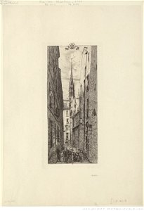
etchings by charles meryon in the bibliothèque nationale de france
meryon (delteil 042)
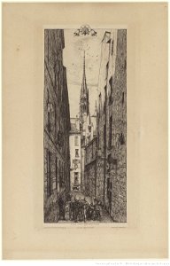
etchings by charles meryon in the bibliothèque nationale de france
meryon (delteil 042)
prints by camille pissarro in the bibliothèque nationale de france
impressionism
etchings by charles meryon in the bibliothèque nationale de france
meryon (delteil 011)
prints by auguste rodin in the bibliothèque nationale de france
modern art,symbolism
drawings by anders zorn in the bibliothèque nationale de france
impressionism
etchings by charles meryon in the bibliothèque nationale de france
meryon (delteil 042)
etchings by charles meryon in the bibliothèque nationale de france
meryon (delteil 011)
prints by auguste rodin in the bibliothèque nationale de france
modern art,symbolism
prints after nicolas poussin in the bibliothèque nationale de france
étienne baudet
château de greifenstein
eugène laville
ponts couverts (strasbourg)
franz hoch
porte des bouchers (strasbourg)
émile schweitzer
porte des bouchers (strasbourg)
émile schweitzer
etchings by charles meryon in the bibliothèque nationale de france
meryon (delteil 042)
prints by odilon redon in the bibliothèque nationale de france
symbolism
prints by auguste rodin in the bibliothèque nationale de france
modern art,symbolism
dinan in painting
andré engel
maps of the armenian kingdom of cilicia
catalan atlas
prints by rembrandt in the bibliothèque nationale de france
dutch golden age painting
prints by rembrandt in the bibliothèque nationale de france
dutch golden age painting
prints by rembrandt in the bibliothèque nationale de france
dutch golden age painting
illustrations of jean de la fontaine's fables by jean-baptiste oudry
nicolas-dauphin de beauvais
17th-century maps of cambridgeshire
old county maps of cambridgeshire
partie orientale du temporel de l'archevesché et eslectorat de mayence - et le comté de reineck - par le sieur sanson... - btv1b53202373t
guillaume sanson
bibliothèque nationale de france
félix robaut
monument national du hartmannswillerkopf
antoine bourdelle
l'alsace divisée en ses principales parties - sçavoir les landgraviats de haute, et basse alsace et le suntgaw - par le sr. sanson... ; cordier sculpsit - btv1b531794616
guillaume sanson
bibliothèque nationale de france
johannes le francq van berkhey
(lettre autographe signée d'andré saglio, dit drésa, à jacques rouché, 21 mars 1919) (manuscrit autographe) - btv1b53150676w
bibliothèque nationale de france
carte de la province de berry (1707) by jaillot
bibliothèque nationale de france
evesché de la rochelle, dédié à... messire henry de laval, évesque de la rochelle par son très humble et très obéisfant serviteur - g. sanson... - btv1b53227146h
bibliothèque nationale de france
1830s maps of puerto rico
nathaniel currier
archevesché et eslectorat de cologne avec ses enclaves dans les pays circonvoisins. tiré des mémoires les plus nouveaux - par le sr sanson... - btv1b532023960
guillaume sanson
bibliothèque nationale de france
tranquillo mollo
bibliothèque nationale de france
hendrik de leth
bibliothèque nationale de france
hendrik de leth
carte particulière des costes de l'afrique qui comprend le royaume de gualata ... - btv1b8595466g
maps by pieter mortier
1730s maps of the philippines
baroque painting
lettre autographe signée d'andré saglio, dit drésa, à jacques rouché, 16 novembre 1923 (manuscrit autographe) - btv1b53150677b
bibliothèque nationale de france
(lettre autographe signée d'andré saglio, dit drésa, à jacques rouché, 21 mars 1919) (manuscrit autographe) - btv1b53150676w
bibliothèque nationale de france
carte particulière des costes de l'afrique qui comprend le royaume de gualata ... - btv1b8595466g
maps by pieter mortier
map of modern syria by philippe de la rué
1650s maps of palestine
1690s maps of the ottoman empire
guillaume sanson
bibliothèque nationale de france
guillaume sanson
bibliothèque nationale de france
guillaume sanson
lettre autographe signée d'andré saglio, dit drésa, à jacques rouché, 16 novembre 1923 (manuscrit autographe) - btv1b53150677b
bibliothèque nationale de france
bibliothèque nationale de france
maps by thomas kitchin
gustave boulanger
orientalism
11101 - 11200 of 14,157
Next page
/ 142